Clemson University spotlights ten architecture student projects
Dezeen School Shows: a waterfront redevelopment that aims to mitigate flooding in Colombia is included in Dezeen's latest school show by students at Clemson University.
Also included is a bridge that takes cues from the landscape of Charleston, USA, and a project that focuses on community initiatives to work towards sustainable spaces.
Clemson University
Institution: Clemson University
School: School of Architecture
Course: Master of Resilient Urban Design
Tutors: Allen Davis, Morgan Gundlach, Charles Kane, Erin Stevens, Bradford Watson and BD Wortham-Galvin
School statement:
"The Master of Resilient Urban Design (MRUD) is designed to empower you with the knowledge and skills to navigate the ever-changing complexities of rapidly growing metropolitan regions.
"The program is founded on an issues-based teamwork model wherein students engage in issues and ask questions based on a design-thinking foundation, enhanced with methodologies and processes from multiple disciplines.
"The MRUD program prepares individuals to engage complex cultural, market and government policy forces through sustainable and resilient urban forms.
"Inclusive of sustainability and cities' abilities to help sustain diverse environments, cultures and economies locally and globally, resiliency also implies the ability of a community to anticipate and recover from present and future challenges.
"As such, the MRUD program seeks to envision not only humane and ennobling places now but to ask 'what if' questions about the city and urban system as a whole."
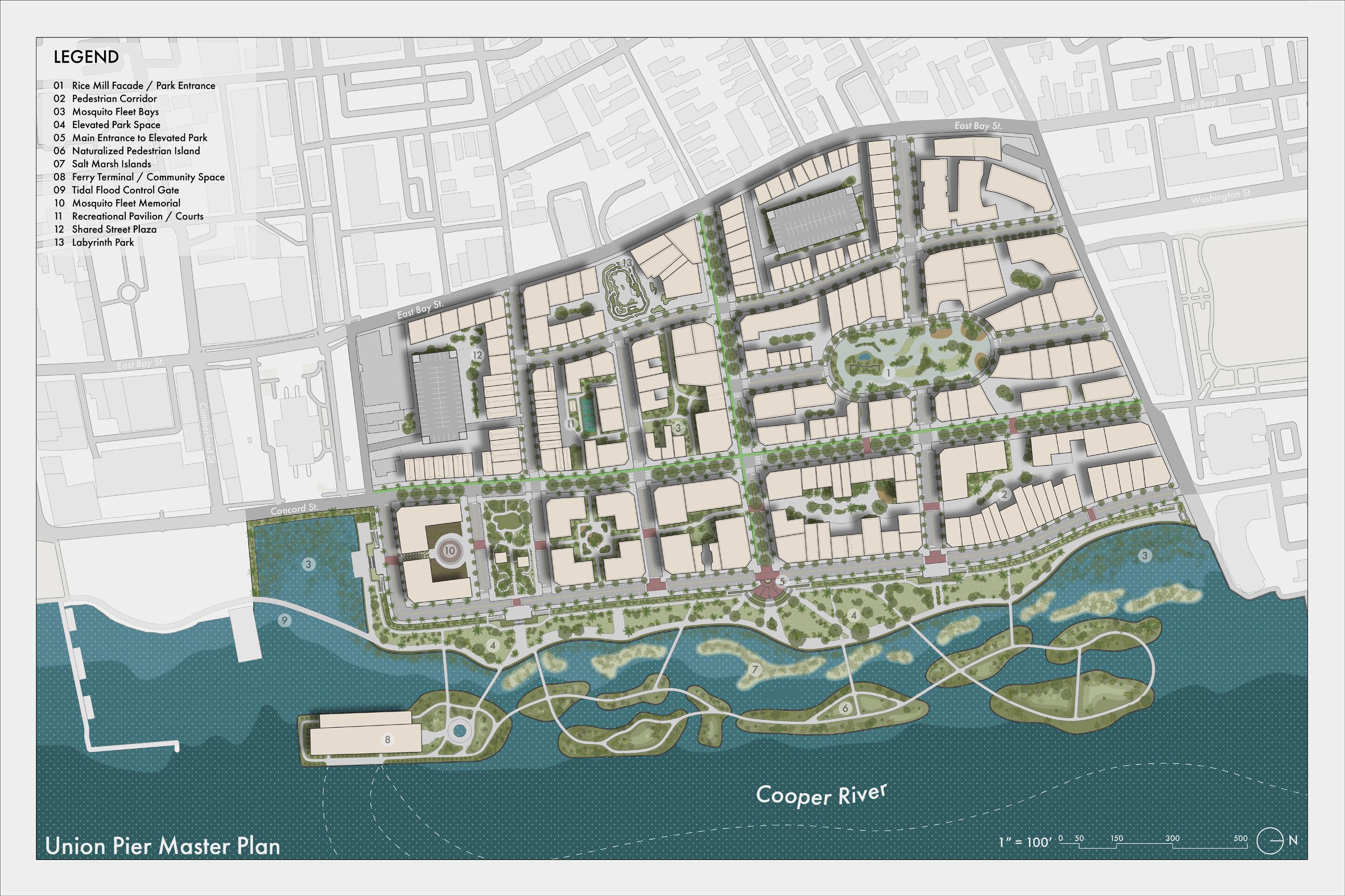
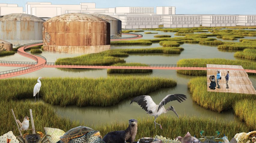
Union Pier Redevelopment by Bryan Stewart and Brian Graham
"A 72-acre industrial shipping site in the heart of downtown Charleston has been slated to be re-incorporated as part of the city – it was built on a mixture of artificially created land and concrete pilings.
"This design incorporates the texture of the historic city grid in order to provide access to this vast stretch of waterfront.
"Furthermore, the existing piers are carved to mimic typical barrier islands and repopulated with plants to reintroduce the historic maritime forests into the peninsula.
"The edge between land and pier is rehabilitated with a perimeter barrier and marshes can help protect and bring nature back to the city to create a contemporary solution to a historic city."
Students: Bryan Stewart and Brian Graham
Course: RUD 8630 – Urban Design Studio 2
Tutors: Erin Stevens and Charles Kane
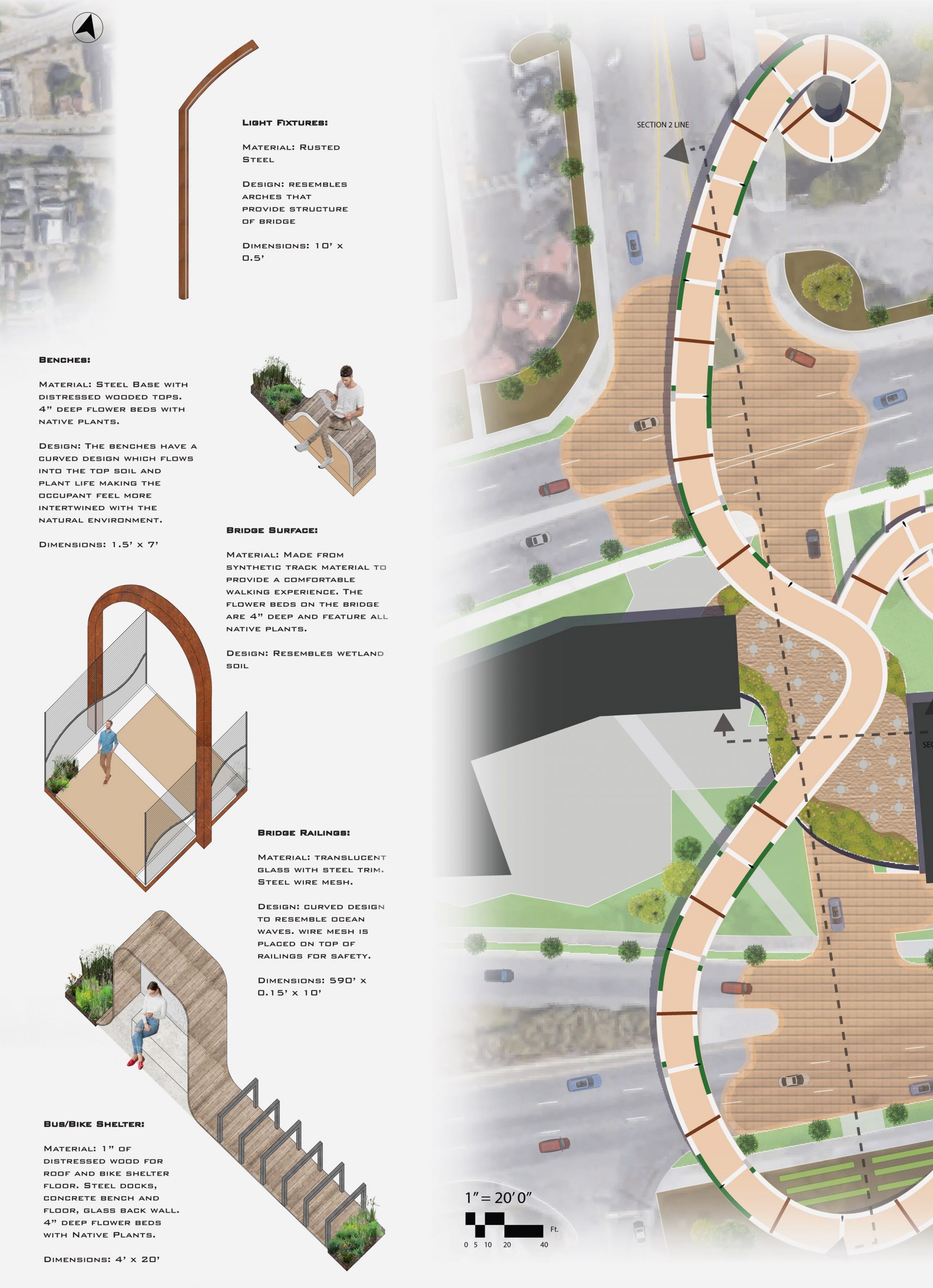
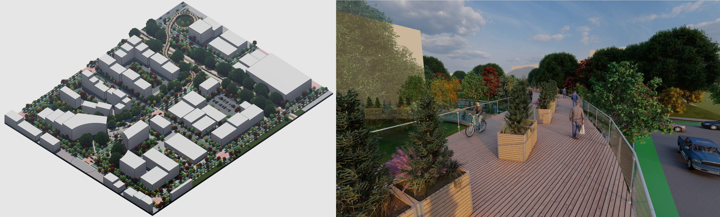
Crosstown Pedestrian Connector by Matthew Brewster
"This pedestrian bridge proposal aims to connect the residential neighbourhood to the north of the site with a medical district to the south.
"A divided highway currently separates the two sides.
"The curvilinear path and amorphous shapes in the design reference the tidal creeks that defined the site before the area was filled in to create more land for the city."
Student: Matthew Brewster
Course: RUD 8660 – RUD 8660 Urban Design Studio 3
Tutors: Erin Stevens and Charles Kane
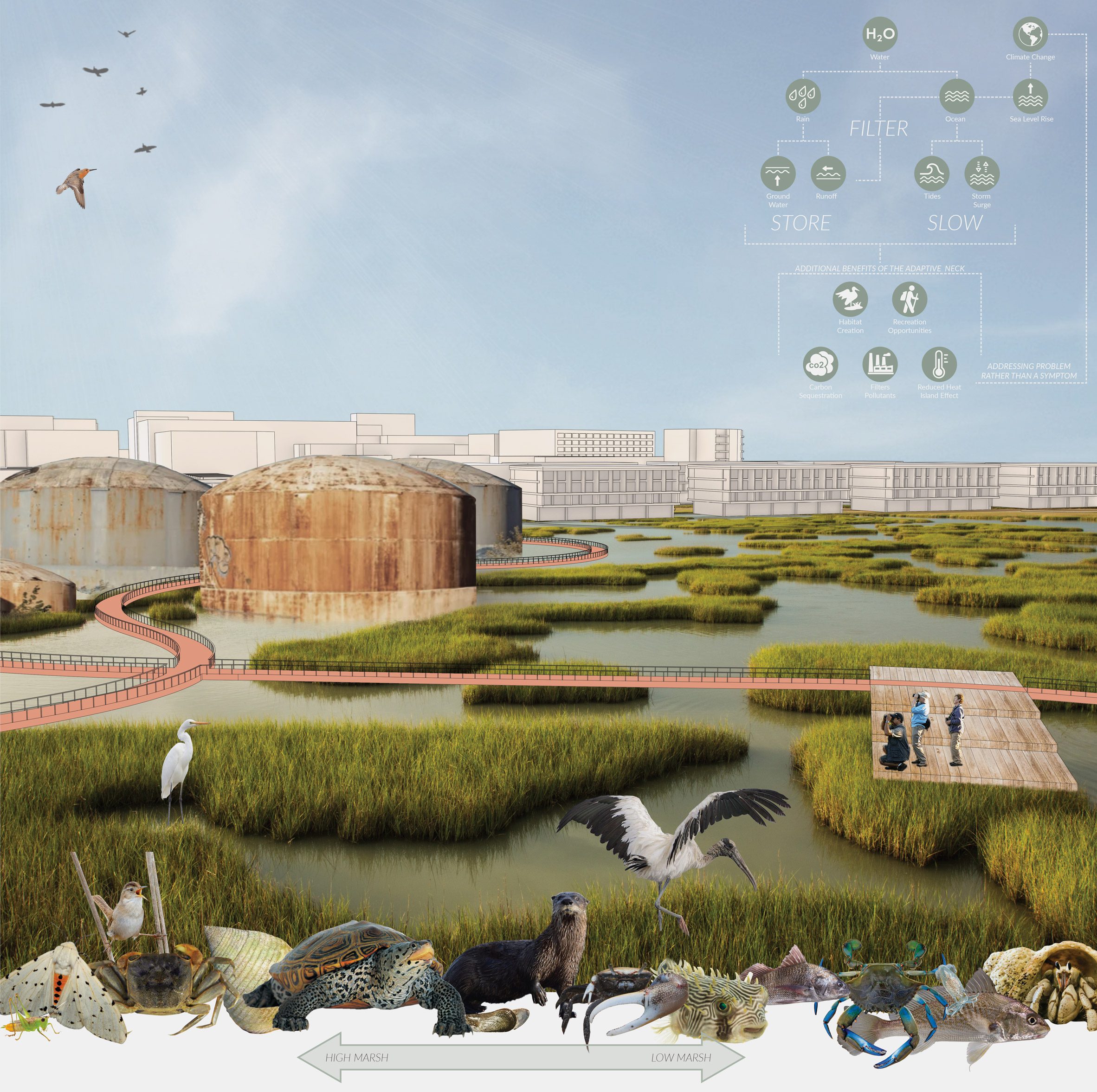
Blue Line by Ray Byrd
"Students were asked to explore design alternatives to the proposed perimeter protection system parallel to the ongoing US ACE 3x3x3 study.
"Focus was placed on honouring cultural, ecological and physical context while developing resilient strategies for urban growth and adaptation to climate risks.
"This was Ray's final design response for his assigned area of the peninsula."
Student: Ray Byrd
Course: RUD 8600 – Urban Design Studio I
Tutors: Erin Stevens, Allen Davis and BD Wortham Galvin
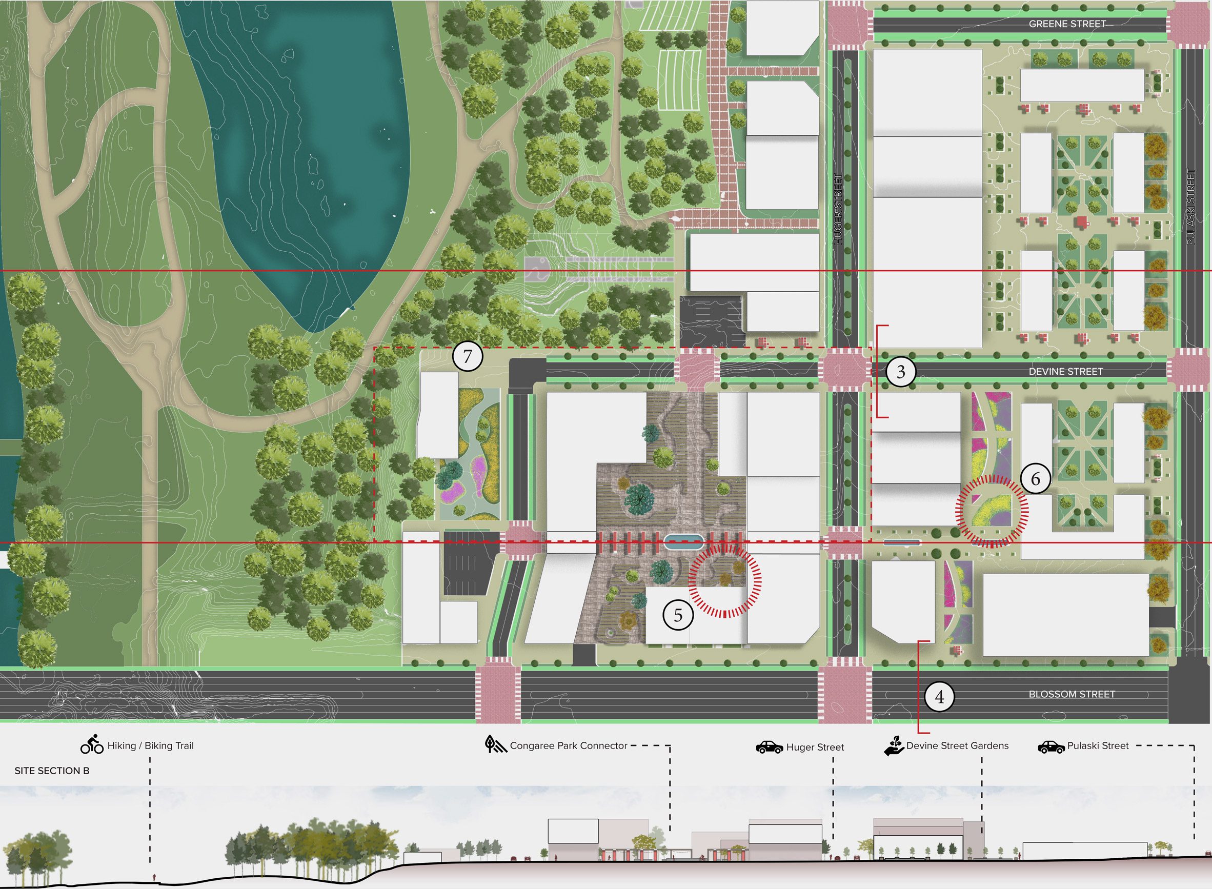
Congaree Riverfront District by Nick Hannah
"This masterplan along the river converts an underutilised piece of land along the edge of the river into an active waterfront and a chance for the citizens of Columbia to re-engage with the water and with nature.
"In the proposal, a large area of the site was allotted as a naturalised, wooded park.
"This space also serves as a stormwater solution because this portion of the city is prone to flooding from run-off and from the river swelling – thus turning a liability into an asset.
"The natural park is contrasted with the more formal park spaces within the revised city grid – each outdoor space serves as a mitigation tool for the town's sweltering heat island effect."
Student: Nick Hannah
Course: RUD 8660 – Urban Design Studio 3
Tutors: Erin Stevens and Charles Kane
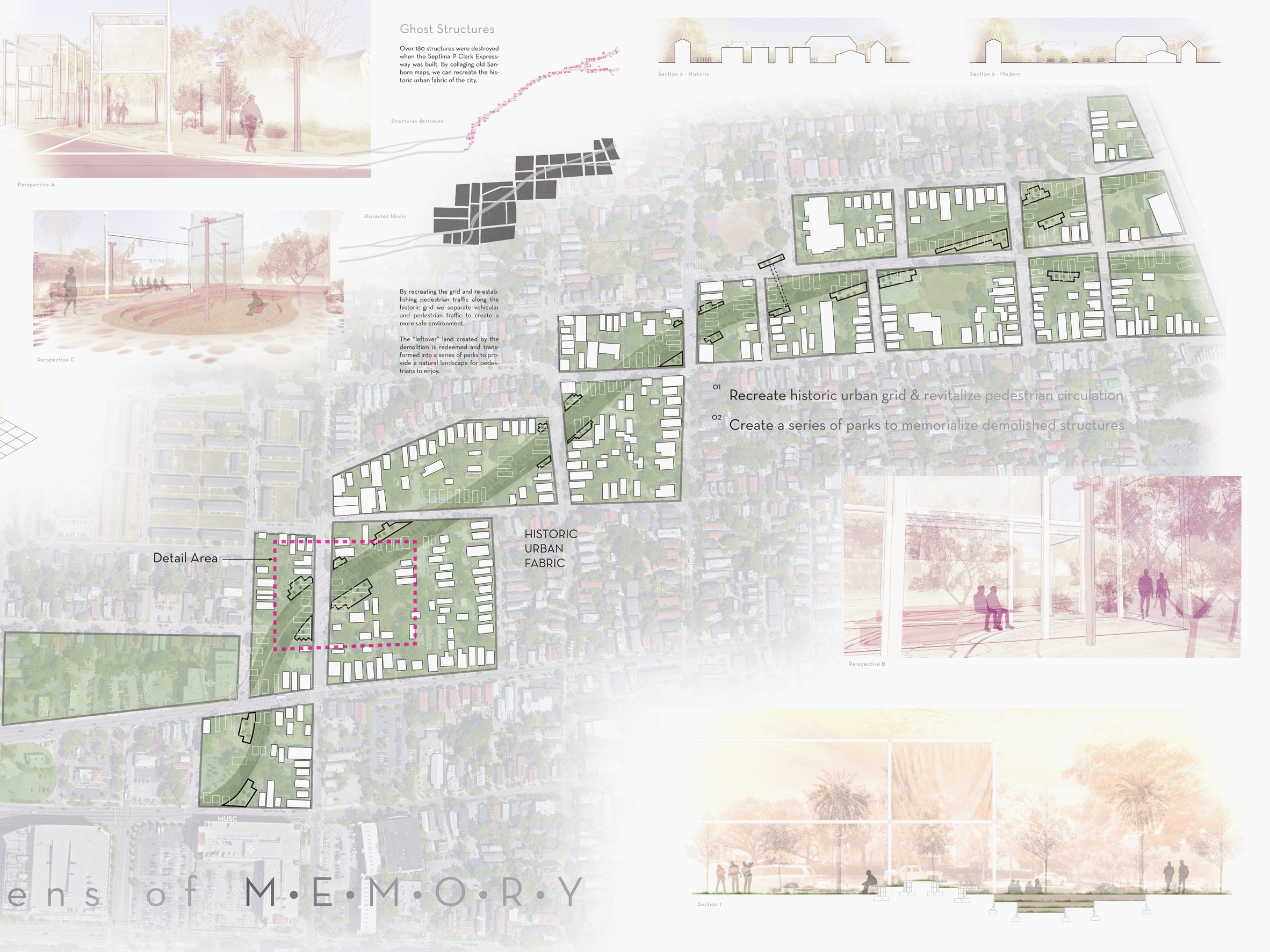
Gardens of Memory by Corey Sosebee
"This project aimed to restitch a working-class neighbourhood that was split by a highway during the 1960s Urban Renewal Program.
"In addition to creating traffic calming measures to make the streets safer for pedestrians to cross, the design reintroduced the memory of demolished structures and the bifurcated city grid through a series of parklets.
"These parklets offer places for gathering and reflection and reference the historical grid and demolished buildings through ground treatment and pavilion structures that trace the historical patterns of the neighbourhood."
Student: Corey Sosebee
Course: RUD 8660 – Urban Design Studio 3
Tutors: Erin Stevens and Charles Kane
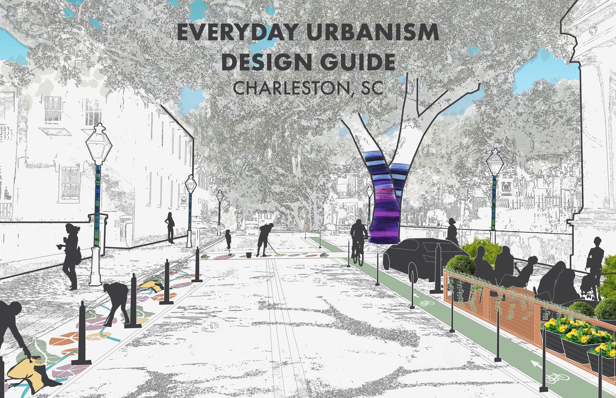
Everyday Urbanism by Catherine Cusack, Nicholas Hannah, Isabelle Holland, Jennifer Jonson, Caroline Lord and Brooke Young
"The City of Charleston has long been lauded for the stewardship of its historic urban fabric and public spaces on the peninsula.
"The Everyday Urbanism Design Guide is offered up as a way to expand and enhance how the city stewards change both on and off the peninsula.
"Following the motto of the city's public agency the Design Division, 'for the common good', the guide emphasises how placemaking can happen for the welfare and wellbeing of the general public."
Students: Catherine Cusack, Nicholas Hannah, Isabelle Holland, Jennifer Jonson, Caroline Lord and Brooke Young
Course: RUD 8640 – Urban Design Seminar 2
Tutors: B.D. Wortham-Galvin and Morgan Gundlach
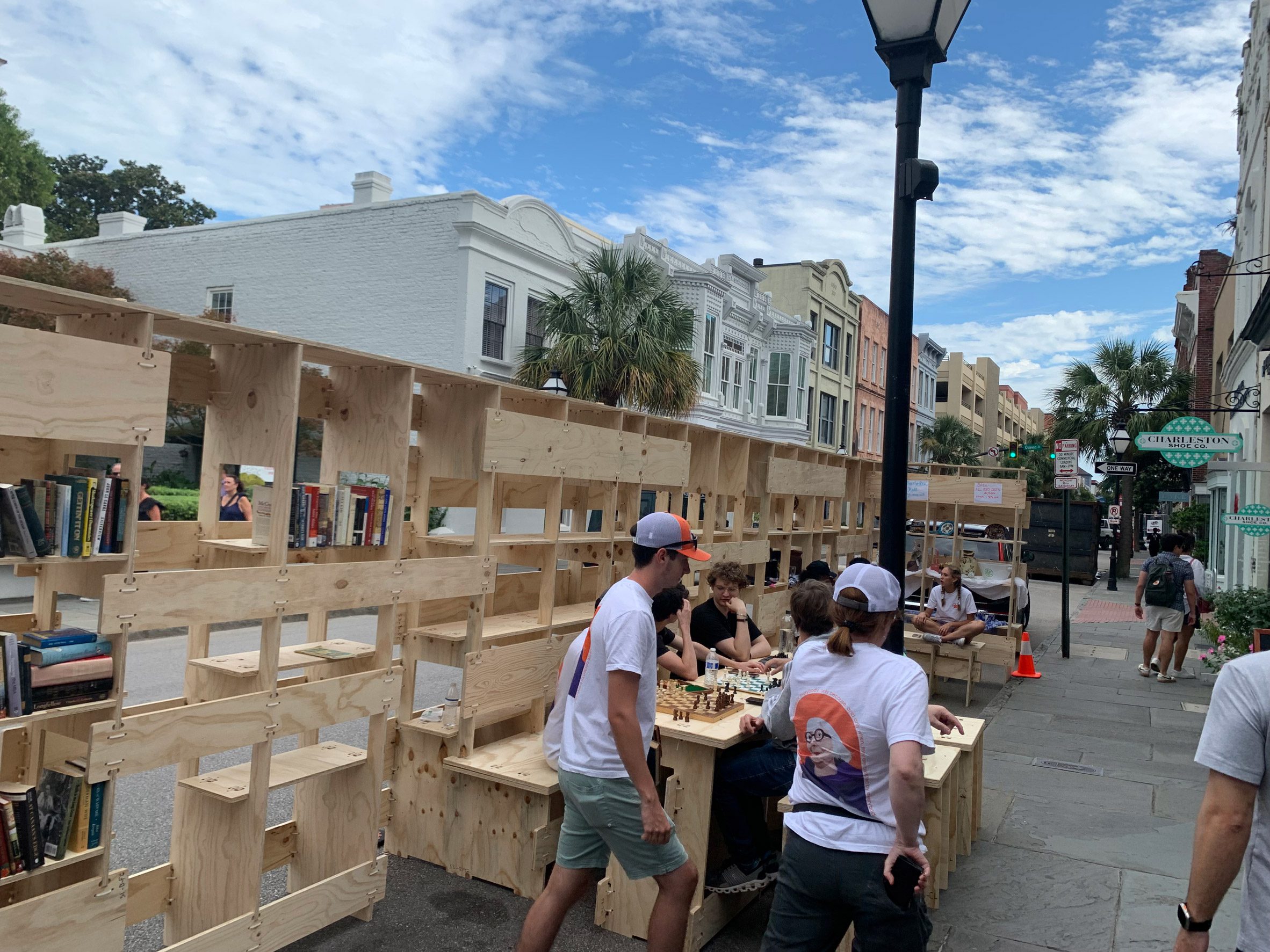
King Street Parklet by Brian Graham, Jillian Grimes, Kayla Madrin, Shea Meena, Ghritika Paul, Rabun Shwany, Bryan Stewart, Treasure Washington and Julia Weaver
"Park(ing) Day is a public participatory project where people across the world temporarily repurpose curbside parking spaces and convert them into public parks and social spaces to advocate for safer, greener streets, alongside presenting local makers' goods for sale and a range of activities for visitors.
"This project was supported by the City of Charleston Civic Design Centre, AJ Architects and JMO Woodworks.
"The MRUD partnered with Metanoia for a parklet in November 2023 in the historic Black neighbourhood of Chicora/Cherokee in North Charleston as part of a Better Block event, leading a series of community events in the run-up to the event.
"The event was attended by around 250 residents and in addition to the parklet pop-up, included a farmers' market produce giveaway, a kids zone, live music, Chicora Elementary choir performance, DJ, radio station presence, food truck and a voter registration booth.
"MRUD's first Better Block collaboration with Metanoia was in 2018 and led to a series of discussions with North Charleston and community leadership and led to the city taking control of Reynolds Avenue from SCDOT, in order for the city to best steward changes to Reynolds Avenue and the surrounding community."
Student: Brian Graham, Jillian Grimes, Kayla Madrin, Shea Meena, Ghritika Paul, Rabun Shwany, Bryan Stewart, Treasure Washington and Julia Weaver
Course: RUD 8610 – Urban Design Seminar 1
Tutors: B.D. Wortham-Galvin and Morgan Gundlach
Columbia Athletic Gateway by Rabun Schwany
"This masterplan for the western edge of Columbia reconnects the city across a railroad line that divides pedestrians from flowing freely between east and west.
"An elevated pedestrian path crosses the divide and doubles as an art walk that extends along a new daylit stream to a proposed art museum."
Student: Rabun Schwany
Course: RUD 8660 – Urban Design Studio 3
Tutors: Erin Stevens and Charles Kane
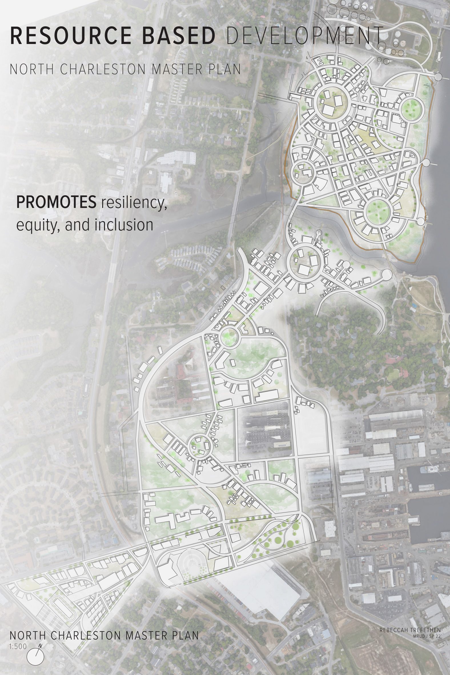
Navy Yard Development by Rebecca Trefethen
"The North Charleston area houses the remnants of an old naval base and an adjacent post-industrial site.
"This project aims to reimagine the area as a human-scaled series of interconnected neighbourhoods.
"Each neighbourhood is defined by a distinct circular park that allows for a network of related but individual characters.
"This new extended community reconnects this swath of the city to the nearby residential zones."
Student: Rebecca Trefethen
Course: RUD 8630 – Urban Design Studio 2
Tutors: Erin Stevens and Charles Kane
Temporal Adaptations by Courtney Wolff
"Students were asked to explore design alternatives to the proposed perimeter protection system parallel to the ongoing US ACE 3x3x3 study.
"Focus was placed on honouring cultural, ecological and physical context while developing resilient strategies for urban growth and adaptation to climate risks.
"This was Courtney's final design response for her assigned area of the peninsula."
Student: Courtney Wolff
Course: RUD 8600 – Urban Design Studio 1
Tutors: Erin Stevens, Allen Davis and BD Wortham Galvin
Partnership content
This school show is a partnership between Dezeen and Clemson University. Find out more about Dezeen partnership content here.